![]()
HOW CINCINNATI GOT ITS NAME
From 1788-1790 the first settlement in the area was called Losantiville. This name was given to the settlement by John Filson, one of the founders of Cincinnati. The name is a compilation of "L" for the Licking River, "os" from the Latin meaning "mouth", "anti" from the Greek meaning "opposite", and "ville" from Anglo-Saxon, meaning "city" or "town". This comes out as "The Town Opposite the Mouth of the Licking". Indian trouble caused the Federal government to build Fort Washington in 1789. The fort was located between Third and Fourth Sts. on the east side of Broadway.
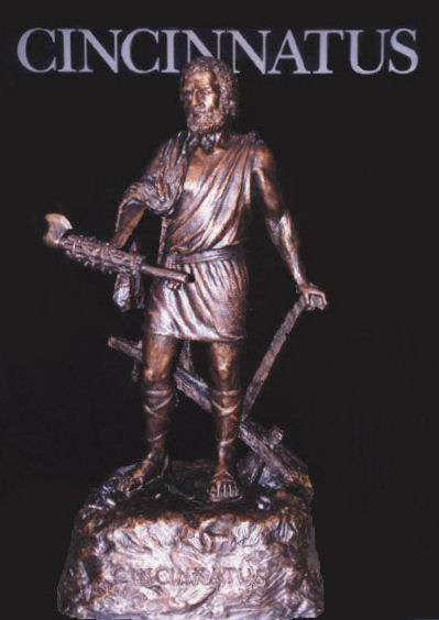
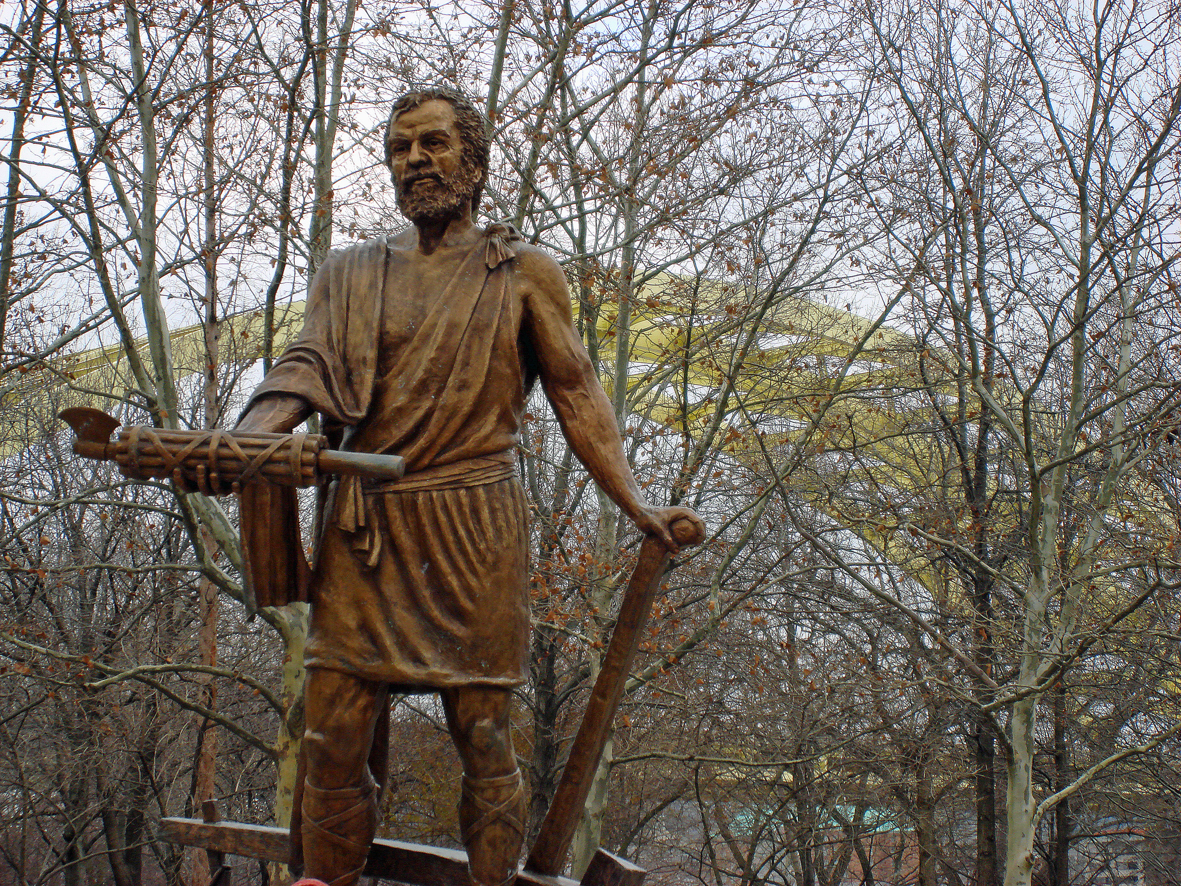
In 1790 General Arthur St. Clair, the first governor of the Northwest Territory and a member of the Society of the Cincinnati, did not like the name Losantiville and changed it to Cincinnati. The Cincinnati Society was named in honor of the Roman general Lucius Quinctius Cincinnatus. He lived in the Fifth century BC. While plowing his fields one day he was told to take command of Rome�s army. Within 15 days he led the army to victory over the enemy. He then went back to his plowing. The Society of the Cincinnati was started by, and consisted of, Continental Army officers of the American Revolution. Cincinnati was incorporated as a town on January 1, 1802. It became a city on February 5, 1819. General St. Clair called the County Hamilton in honor of the first Secretary of the Treasury of the new nation. The first Mayor Of Cincinnati was Isaac Burnet.
Not postcards
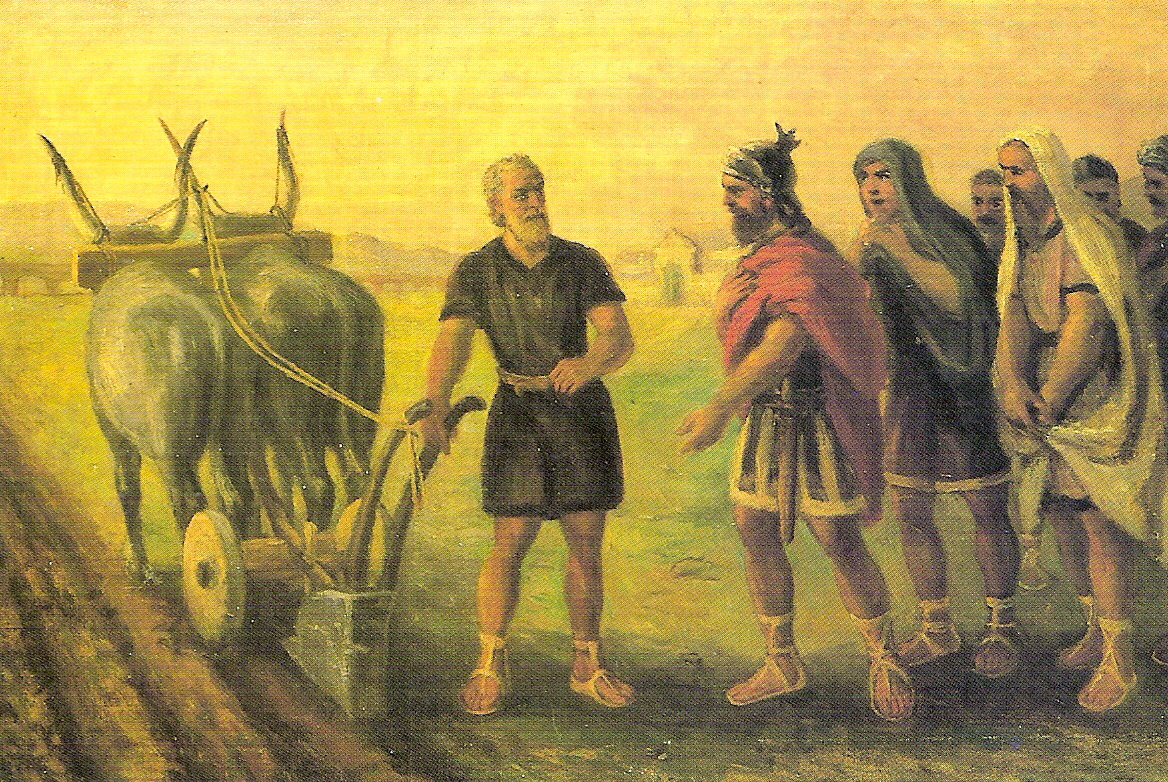
Cincinnatus plowing his land.
Eden
Park Statue
SEVEN HILLS ?
According to popular belief, Cincinnati was, like Rome, built on seven hills. Nobody seems to know, if true, what the original seven hills were. The library has four lists on which only two hills are in agreement - Mount Auburn and Mt. Adams. three of them agree on Walnut Hills and Fairmount. The other hills mentioned are Clifton Heights, Price Hill, Fairview Heights, Mt. Harrison (?), Vine St. Hill, College Hill, Clifton, Tusculum, Mt. Lookout, Mt. Hope, Mt. Echo. Mt. Airy is not mentioned on any of the lists. Feel free to make your own list.
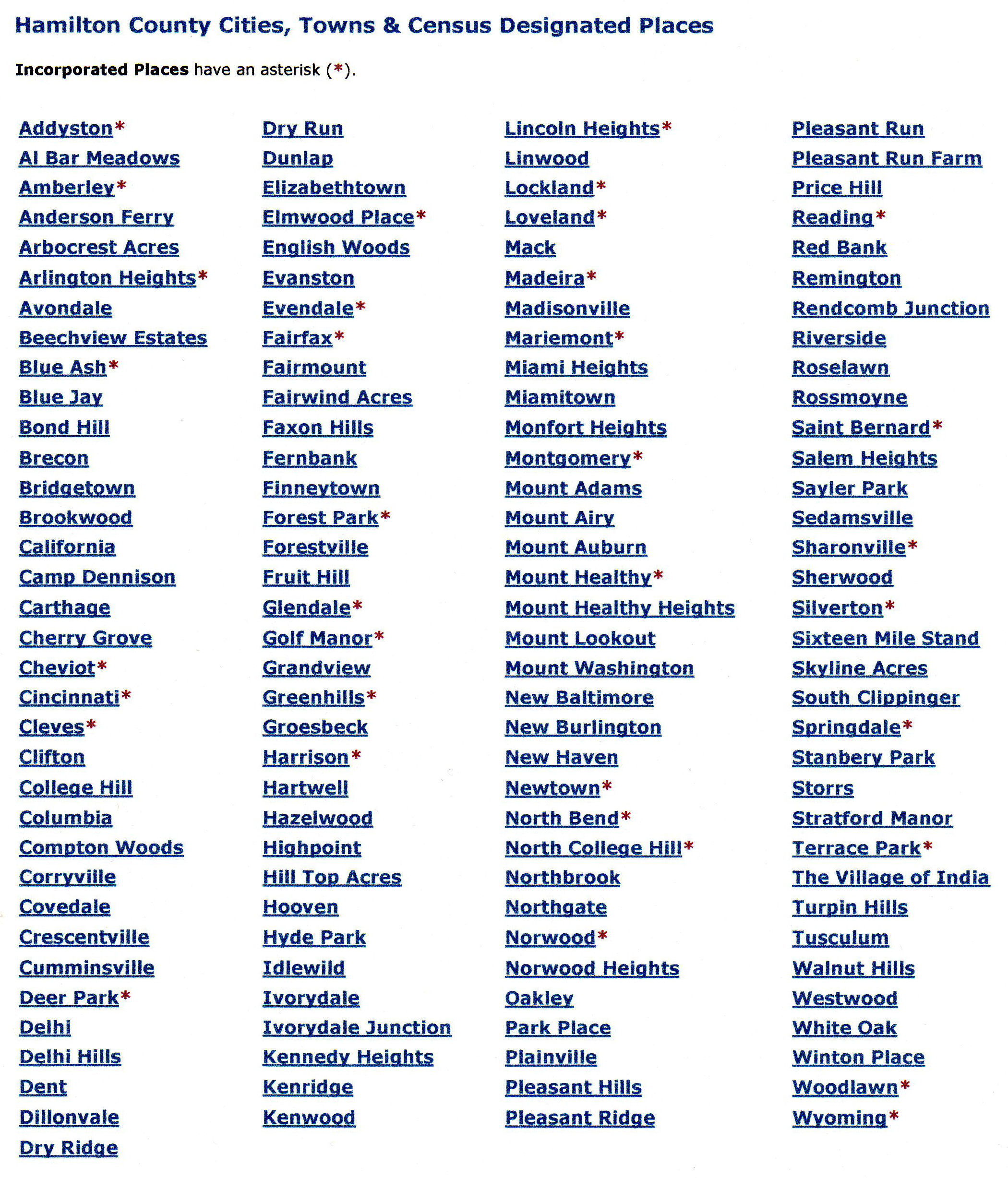
MUNICIPALITIES & COMMUNITIES OF HAMILTON COUNTY
COUNTY SEAT: Cincinnati
CITIES:
Blue Ash - Cheviot - Cincinnati - Deer Park - Fairfield - Forest Park - Harrison
- Indian Hill - Loveland - Madeira - Milford - Montgomery - Mount Healthy -
North College Hill - Norwood - Reading - Sharonville - Silverton -
Springdale - St. Bernard - Wyoming.
VILLAGES:
Addyston - Amberley Village - Arlington Heights - Cleves - Elmwood Place -
Evendale - Fairfax - Glendale - Golf Manor - Greenhills - Lincoln Heights -
Lockland - Mariemont - Newtown - North Bend - Terrace Park - Woodlawn.
TOWNSHIPS:
Anderson - Colerain - Columbia - Crosby - Delhi - Green - Harrison - Miami -
Springfield - Sycamore - Symmes - Whitewater.
*CDPs:
* CDPs = Census-Designated Places. A dense population of people that are not within an incorporated area, but is locally identified by a name.
The list above is a much more comprehensive list than the first list but it is not separated into Villages, Unincorporated Communities and Community Entertainment Districts like the first list is.
CINCINNATI FIRSTS
Woodward High School was the first free public school west of the Alleghenies.
First wire suspension bridge west of the Alleghenies crossed Canal & Race.
The first American Turner Society was founded in Over-The-Rhine.
The first bronze art foundry west of the Alleghenies.
Tyler Davidson Fountain was first in the world to dispense ice water for drinking.
Fountain was also first one of importance and artistic merit in the U.S.
First observatory built by public subscription (1843 dedicated by John Quincy Adams hence the name Mount Adams)
First art museum (1886) in its own building west of the Alleghenies.
First settlement in Ohio to publish a newspaper. (1793)
The first airmail (by hot air balloon) July 4, 1835.
First city in America to hold a saengerfest. (song fest) (1849)
First paid municipal Fire Department in 1853.
First successful steam fire engine in 1853.
First annual Industrial Exposition in America in 1870.
First professional baseball team. (1869)
First team to play games under lights. (5/24/35)
First time President throws out opening day baseball. (William Howard Taft, April 14, 1910)
First woman to own a Major League Baseball team. (Margaret "Marge" Schott, 1984)
First city to establish a weather bureau, also first to issue a weather bulletin. (1869)
The first & only city to own a Railroad. (Cincinnati Southern in 1880)
The first municipal university. (1870)
The nations first Jewish hospital (1850). Also first Jewish Theological College in the U.S. The Hebron Union College. (1875)
First licensed educational TV station. (WCET-TV in 1954)
The first concrete skyscraper. (Ingalls Building, 4th & Vine in 1902)
First shot fired in WW1. (Robert Braley)
The nations first interstate electric bus line left Dixie Terminal on 7/11/1937 to Northern Kentucky.
The first city to publish greeting cards-Gibson Greeting Card Co. (1850).
First heart-lung machine (1952). Developed at Children's Hospital Medical Center.
First large manufacturing operation to be started and run by a woman. Maria Longworth Nichols Storer and the famous Rookwood Pottery started in 1880.
First woman buried in Arlington National Cemetery. (Helen "Nellie" Taft, 1943)
First grocery store to make its own bread. (Kroger, 1902)
THIS AND THAT
The area between Broadway, 6th, 7th,
& Culvert Sts. around the years of the Civil War was known as Bucktown.
There were so many murders at 6th & Broadway
the area was called "Dead Man's Corner". By 1890 Bucktown had become
almost civilized. It was written that "sometimes several nights would pass
without anyone being killed" (W. P. Dabney).
The southwest corner of 5th and Vine was known as the "Nasty
Corner" in the late 19th century. This was because there were so many
saloons along that stretch that the sidewalks were filled with loiterers and
drunks. Women were advised to avoid this area where they were likely to be
exposed to bad language and squirts of tobacco juice. The name came from the
corruption of the land owners name, Mr. Naste. The area was improved with the
construction of the Carew Building (the building before the Carew Tower was
built).
The section of 4th Street between Vine and Walnut streets was known
as "Gamblers Row" because there were at least 30 faro games being run
there in the 1870s.
The area of Broadway and Front Streets was known as Battle Row
because of many fights that started in the Silver Moon Saloon and spilled out
into the street.
The area where the Playhouse in the Park stands was known as
Butcher's Hill . This was the area where the Mount Adams gangs fought the Fulton
gangs, (Fulton was where the shipyards for building the steamboats were
located). The name probably came from the fact that it overlooked the valley of
Deer Creek, where the slaughter houses were. Those factories gave Deer Creek the
nickname of Bloody Run, (which gave the name to Bloody Run Road, later renamed
Victory Parkway after WWI.
The Bluff above Deer Creek, west of Reading Road, was called Goat
Hill because some of the people living there raised goats. Nanny Goat Hill and
Billy Goat Hill were the names given to two higher knobs of land in that area.
The western part of the levee along the Ohio was called Bratwurst
Row when it was primarily a German Settlement. It was changed to Sausage Row
after The Irish moved in. The eastern part of the levee was called Rat Hole Row,
where the stevedores and steamboat workers lived. O'Bryonville was first called
Dutchtown before the area turned from German to Irish in nature.
Stretched along the Ohio Bank east of downtown were Pendleton,
Fleettown, and Fulton, in that order. Beyond them were Columbia, Tusculum, and
Linwood, which retained their names. Pendleton, near Sawyer Point, was built
around the roundhouse of the Little Miami Railroad. Fleettown was where the
riverboats tied up for repair, and Fulton was where the shipyards for building
the steamboats were located.
Frenchman's Corner and Goosetown were neighborhoods around Spring
Grove And Hamilton Ave. Wooden Shoe Hollow was on lower Winton Road near Spring
Grove Cemetery. Areas of Cumminsville were called Gary Owen and Hammeltown.
Kay's Corner became Peeble's Corner.
WHERE SOME NAMES CAME FROM
NORTH BEND;
The area marks the last great northern bend in the Ohio River. The course from
here to the Mississippi River is always westward and southward.
CLEVES and SYMMES; Both names come from the name of one of the original
settlers, John Cleves Symmes who originally owned 1,000,000 acres of land.
Cleves was his Mother's name.
CAMP WASHINGTON; General Wayne's Army had one of his camps here.
FULTON; Up-river from Cincinnati at the bend in the river it is where the ship
yards & dry docks were located. It was appropriately named after the
steamboat's inventor.
PENDLETON; The whole area was once owned by a man named Pendleton (grandfather
of Jacob Strader).
READING; One of the original settlers in that area came from Reading, England.
SHARONVILLE; Was named after the Biblical Sharon, where the roses bloomed.
AVONDALE; There are two explanations: The mother of Stephen Burton, who was a
lover of Shakespeare, (first Mayor of Avondale, Burton Ave., Burton Elementary)
Suggested the name in honor of the Bard of Avon. The other explanation is that
there was a omnibus who made the trip to Cincinnati and back to the town once a
day. The name of the omnibus was "The Avon". Avondale is not a leap.
GLENDALE; The name comes from a Mr. Glenn the owner of Glenn Farm that was in
the area.
WYOMING; The people in the area threw a party and Mr. Reilly (Reilly Road) asked
for suggestions and Wyoming was the result.
HARTWELL; Named after John W. Hartwell, the director of the C. H. & D.
Railroad which had made the town possible
MONTGOMERY; The founder of the town came from the town of Montgomery in New
York.
HARRISON; Obviously named after William Henry Harrison.
HAMILTON COUNTY; Alexander Hamilton.
BURNET WOODS; Judge Jacob Burnet.
LYTLE PARK; General William H. Lytle whose home was where the park was
established.
AULT PARK; Named after Lee A. Ault who donated the land.
CUMMINSVILLE; Named after an early settler by the name of Cummins.
SYCAMORE STREET; It is called that because of a large sycamore tree that stood on the
Ohio River bank at the foot of the street.
LUDLOW AVENUE; Named after Israel Ludlow one of the first surveyors in the
county.
WALNUT HILLS; The hills at that time were covered with walnut trees.
MILFORD; It was in a ford and had a mill.
NEWTOWN; The name itself is an explanation.
VERNONVILLE; Near what is now Oak and Burnet was a florist who called his place
the Vernon. In 1859 it was suggested that the little settlement be called Vernon
Gardens which, eventually, became Vernonville.
COLERAIN; (town & Street) were named by John Dunlop, friend &
advisor of John Cleves Symmes, who was born in Colerain, Ireland.
MADEIRA; It is the name of an early settler, John Madeira who was also treasurer
of the Marietta and Cincinnati Railroad, forerunner of the B&O mainline that
ran through the town.
CARTHAGE-TUSCULUM HEIGHTS; Only names (with Cincinnati) that came from the
Ancient World.
MT. AUBURN; From Goldsmith's "Sweet Auburn, Loveliest Village of the
Plain".
BOND HILL; Bond Hill is actually in a valley with hills surrounding it. The
founders thought that if they called their low ground a hill they could attract
more settlers.
CAMARGO; In 1847 it was called Eden. The postmaster read about Camargo
in the Mexican War and loved the name so much he petitioned the P.O. Dept. to
change the name. It was granted.
EVENDALE; The land in this area is flat as a billiard table.
RED BANK; In that spot is a great bank of reddish sand and gravel.
TERRACE PARK; The land here stands on one of the great post glacial
terraces and is a favorite site for geologists.
ANDERSON TOWNSHIP; Named after Richard Clough Anderson. General Anderson
was a surveyor sent here after the Revolutionary War. He is also responsible for
CLOUGH PIKE & CLOUGH ROAD..
MILL CREEK; Although there are none there now and has not had one since the
early 1800s, there used to be a mill on it.
LOVELAND; No it was not named by a lovesick settler. It was named after a
Colonel Loveland.
CAMP DENNISON; Was a Civil War training camp named for the Governor of Ohio.
LOCKLAND; Named for the many locks it had for the Miami Erie Canal.
CHEVIOT; Probably named for the Cheviot Hills of Scotland.
ADDYSTON; Named for Matthew Addy an industrialist who established the
manufacturing plant Matthew Eddy & Co. in the town.
IVORYDALE; Named for a soap product of P.&G.
MARIEMONT; Named for its founder Mrs. Mary J. Emery.
PRICE HILL; Named for the family that owned most of the land there and was once
known as Prices' Hill.
KENNEDY; Named for the Kennedy family who once owned the land the town sits on.
SILVERTON; The middle name of the engineer who laid the original
track for the railroad was Silver and as a thank you a stop was named Silverton
for him which has since become quite a town.
ROSE HILL-AVON HILLS-BEECHMONT; Are all taken from poetry.
HYDE PARK; Named for Hyde Park in London.
NORWOOD; Originally known as Sharpsburg apparently a Young Women in Sharpsburg
infancy did not like this name and she called it Norwood which was the name of
her husband. Sharpsburg only contained 2 houses at the time.
COLLEGE HILL; Got its name because of the college that was there. Known as
Farmers College. Over the years it became known as Belmont Academy and then the
Ohio Military Institute.
CLIFTON; The name came from an old farm known as the Clifton Farms which was
very large.
LAFAYETTE AVENUE; Named for the bank that eventually took over Clifton Farms. It
was this bank that subdivided the property and began the actual settlement of
Clifton.
RIVERSIDE; Originally was called "South Bend" by John Cleves Symmes to
balance his own North Bend. Saylor Park was once called Home City.
BRACKEN ROAD; The Bracken family were early pioneers.
FERGUSON ROAD; Named after Alexander Ferguson, an extensive landowner and
"Father" of Cincinnati's Southern Railroad.
When Colonel Israel Ludlow became the surveyor of Cincinnati he laid out the city's streets like those of Philadelphia which was, at that time, the nation's capital and largest city. He laid out the city's streets in straight lines with the river as the main axis. He even named many of the streets like those in Philadelphia, using numbers and native tree names. The main streets were 60 to 66 feet wide except for Broadway which was 100 feet wide. Originally, each square was divided into eight lots of 99 by 198 feet. The busiest streets in the first decade was Front and Water Streets which ran east-west along the river, and Broadway and Main streets which ran north-south.
CHANGING STREET NAMES
Broadway was first called Eastern Row.
Walnut Street was originally called Cider Street.
Central Avenue was known as Western Row.
Reading Road was Hunt Street.
12th Street east of Main was called Abigail.
13th Street east of Main was called Woodward.
14th Street between Vine and Main was called Allison.
Woodward Street was Franklin.
Yukon was Hanover Street
McMicken was Hamilton Road.
Lang Street was Locust Street.
Frintz was Oak Street.
Stonewall was Hamburg Street.
German Street to English Street.
Bismarck Street to Montreal Street.
Berlin Street to Woodrow Street.
Brunswick Street to Edgecliff Point.
Frankfort Street to Connecticut Avenue.
Hanover Street to Yukon Street.
Hapsburg Street to Merimac Street.
Schumann Street to Meredith Drive.
Vienna Street to Panama Street
Humboldt Street to W. H. Taft Road.
Hamburg became Stonewall.
Bloody Run Boulevard became Victory Boulevard.
Crookshank Road became Glenmore Avenue.
Western Avenue became Boudinot Avenue.
Aberfeldy Avenue became Koenig Avenue.
Central Avenue became Fairmount Avenue.
Spring Street became Vinton Street.
Kincaid Street became Bartlett Street.
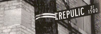
When they changed the name of Bremen Street to Republic Street during WWI they could not spell Republic.
1912 MAP
The 1912 Rand-McNally map above has been reduced by 40%, but it is still VERY large so be prepared to wait while it loads. It is the most detailed and clear map that I have put up, showing all streetcar routes and, of course, the Canal route.
DELTIOLOGY
The collecting of postcards is known as Deltiology. In 1945 professor Randall Rhoades of Ashland, Ohio gave the postcard hobby its official name. It is a combination of the Greek words "DELTION" meaning a small picture and "LOGOS" meaning the science or knowledge of a subject.
DELTIOGRAPH A postcard
STANDARD RATE FOR U.S. POSTCARDS
Pre 1898, no special postcard rate, postage was 2 cents.
19 May 1898 - 1 Jan 1952 *(except 2 periods below), 1 cent.
*Twice the rate was temporarily raised to 2 cents, 2 Nov 1917 - 1 July 1919 (WWI) & 15 April 1925 - 30 June 1928.
1 Jan 1952 - 1 Aug 1958, 2 cents
1 Aug 1958 - 7 Jan 1963, 3 cents
7 Jan 1963 - 7 Jan 1968, 4 cents
7 Jan 1968 - 16 May 1971, 5 cents
16 May 1971 - 2 Mar 1974, 6 cents
2 Mar 1974 - 14 Sept 1975, 8 cents
14 Sept 1975 - 31 Dec 1975, 7 cents
31 Dec 1975 - 29 May 1978, 9 cents
29 May 1978 - 22 Mar 1981, 10 cents
22 Mar 1981 - 1 Nov 1981, 12 cents
1 Nov 1981 - 17 Feb 1985, 13 cents
17 Feb 1985 - 3 Apr 1988 14 cents
3 Apr 1988 - 3 Feb 1991, 15 cents
3 Feb 1991 - 1 Jan 1995, 19 cents
1 Jan 1995 - 1 July 2001, 20 cents
1 July 2001 - 30 June 2002, 21 cents
30 June 2002 - 8 Jan 2006, 23 cents
8 Jan 2006 - 13 May 2007, 24 cents
13 May 2007 - 12 May 2008, 26 cents
12 May 2008 - 11 May 2009, 27 cents
11 May 2009 .........................28 cents
17 April 2011 ........................29 cents
22 January 2012 ....................32 cents
27 January 2013 ....................33 cents
26 January 2014.....................34 cents
POSTCARD SHOP LOCATIONS
Kramer Art Co.-15 East Pearl Street.
Feicke-Desch Printing Co. (successor to Norwood Souvenir)-s. e. corner 5th & Sycamore (fourth floor).
Charles Huber-39 Emery Arcade.
Powell Bros.-315 Central Avenue.
James K. Stewart-17 Emery Arcade. (He also had shops in Newport and Covington Kentucky).
Gibson & Perin Co.-121 West Fourth Street.
Tom Jones Art Co.-402 Pike Street. (8th floor).
George Houston-121 Opera Place. (3rd floor).
Max Weil & Co.-16 East 12th Street.
Young & Carl Photographers-n. w. corner 7th & Vine. (701-707)
Illustrated Cincinnati Pub. Co.-508 Vine street. (Lyric Building)
Walter B. Oelze-631 West McMicken Avenue.
Louis B. Beck Jr.- 1310 Vine St.
Cincinnati Card Co.- 322 W. 4th St. Flat 45 also known as Queen City Post Card Co.
Economy Post Card Co.- 451 Grand Ave.
George Toon- 315 Central Ave.
A SHORT HISTORY OF THE POSTCARD IN THE UNITED STATES
PIONEER ERA (1867 - 1898)
The Pioneer period predates the officially sanctioned private postcards. They are only rarely labeled Postcard or Post Card on the stamp side, but may be called Souvenir or Mail Card. Do not confuse Postal Cards (cards issued by the Post Office) with Postcards. Pioneer cards did not qualify for the one-cent postage rate that applied to the government issued Postal Cards, Pioneer cards required a 2 cent adhesive stamp. Although there were earlier scattered issues, most pioneer cards in today's collections begin with the cards placed on sale at the Columbian Exposition in Chicago, Illinois on May 1, 1893. These were illustrations on government printed postal cards and on privately printed souvenir cards. Writing was not permitted on the address side of the card.
PRIVATE MAILING CARD ERA (1898 - 1901)
On May 19, 1898 private printers were granted permission, by an act of congress, to print and sell cards that bore the inscription 'Private Mailing Card'. The law went into effect on July 1, 1898.Today we call these cards 'PMC's'. Postage was now only a 1 cent adhesive stamp. Note that some of these cards are Pioneers that were overprinted or reprinted to conform to the new Postal Regulations. Many American printers began to take postcards seriously. Writing was still not permitted on the address side, however many publishers often left a wide border on the side or bottom of the view side so a short message could be added.
POSTCARD ERA (1901 - 1907)
The use of the word 'POST CARD' was granted by the government to private printers on December 4, 1901. In this era private citizens began to take black and white photographs and have them printed on paper with post card backs. Writing was still not permitted on the address side.
UNDIVIDED BACK ERA (1893 - 1907)
The above three eras can also be grouped into the general heading of 'undivided back'. The United States Post Office Dept. required "nothing but the address" on the back of postcards during this period, so people had to write any messages on the front or picture side.
DIVIDED BACK ERA (1907 - 1914)
Post cards with a divided back, that is with a vertical line down the middle, were permitted starting March 1, 1907. The address to be written on the right side and written messages to be on the left. Many millions of cards were printed during this period. Up until this point most cards had been printed in Germany who were far ahead of this country in the lithographic processes. With the advent of World War One, the supply of post cards had to come from England and the United States.
WHITE BORDER ERA (1915 - 1930)
Up until the first world war postcards were mainly printed overseas in Germany using the lithograph process which resulted in very beautiful cards. After WWI started all production from overseas, of course, ceased. Most of our post cards were printed in the USA during this period. To save ink, and to make them look more like photographs people were familiar with, a border was left around the view thus we classify them as 'White Border' cards. High cost of labor, inexperience and public taste caused the production of poor quality cards. High competition in a narrowing market caused many publishers to go out of business. Many later cards also had white borders, but it was in this period that the style was introduced and became fashionable.
LINEN ERA (1930 - 1945)
New printing processes allowed printing on post cards with a high rag content that caused a 'linen like' finish. These cheap cards allowed the use of gaudy dyes for coloring. The firm of Curt Teich flourished with their line of linen postcards. Many important events in history were recorded on these cards. Other types of cards were produced during this period, but the Linen was numerically dominant.
PHOTO CHROME ERA (1939 TO PRESENT)
The 'chrome' post cards started to dominate the market soon after they were launched by the Union Oil Company in their western service stations in 1939. Mike Roberts pioneered with his 'WESCO' cards soon after World War II. They tend to be glossy and slick in appearance. Most are printed in color although some are black and white. Chrome is derived from Kodachrome. Three dimensional post cards also appeared in this era.
CONTINENTAL ERA (1970 TO PRESENT)
The Continental card is made by the same process as the Chrome cards, but are larger. Almost all cards before this were using the standard postcard size of about 3.5 x 5.5 inches. The newer Continental cards are 4 x 6 inches. Continental cards pretty well dominate the market today.
The above classifications should not be considered as hard and fast rules. There are exceptions to each classification. They should be considered as clues to when a card was published, but are not sufficient in themselves to date any card with certainty.
DATING REAL PHOTOS
Real Photo postcards started around 1902 with the introduction of the Kodak No. 3a Folding Pocket Kodak. The camera used postcard-size film that were developed on to paper with postcard backs. and have been used continuously to this day. They are distinguished from commercially printed photographic images by being printed on photograph paper with a preprinted postcard back. Real photo postcards are more desirable than commercially printed cards. the majority of real photos are one of a kind, while commercially produced cards were produced in large quantities. One way to tell if a card is a real photo or not is by using a magnifying glass. Most picture postcards were made from photographs, but they have been printed by other processes, commonly lithography. Lithographs are screened (made up of small dots). Real photos have a continuous gradation. There are however, printing processes that produce photographic reproductions without the dot-pattern of a screen, such as the Albertype method. Usually a real photo, without a stamp, can be dated within a range of years by the design of the stamp box. Here are some of the earliest inscriptions.
AGFA ANSCO 1930-1940s
ANSCO (2 STARS AT TOP AND BOTTOM) 1940-1960
ARGO 1905-1920
ARTURA 1910-1924
AZO (SQUARES IN CORNERS) 1926-1940s
AZO (4 TRIANGLES POINTED UP) 1904-1918
AZO (2 TRIANGLES UP, 2 DOWN) 1918-1930
AZO (DIAMONDS IN CORNERS) 1907-1909
AZO (EMPTY CORNERS) 1922-1926
CYKO 1904-1920s
DEFENDER (DIAMONDS ABOVE AND BELOW) 1910-1920
DEFENDER (DIAMONDS INSIDE) 1920-1940
DEVOLITE PEERLESS 1950-
DOPS 1925-1942
EKC 1939-1950
EKKP 1904-1950
EKO 1942-1970
KODAK 1950-NOW
KRUXO 1907-1920s
KRUXO (Xs IN CORNERS) 1910-1920s
NOKO 1907-1920s
PMO 1907-1915
SAILBOAT IN CIRCLE 1905-1908
SOLIO (DIAMONDS IN CORNERS) 1903-1920s
VELOX (SQUARES IN CORNERS) 1901-1914
VELOX (DIAMONDS IN CORNERS) 1907-1914
VELOX (4 TRIANGLES POINTED UP) 1909-1914
VITAVA 1925-1934
THE STAMP
We must not forget about the stamp, after all without this little piece of paper our postcard would not get very far.
A Little Ditty
There was a little postage stamp,
No bigger than your thumb,
But still it stuck right on the job
Until its work was done.
They licked it and pounded it
Till it would make you sick!
But the more it took the licking
The tighter it would stick.
Let's all be like the postage stamp
In playing Life's big game,
And stick to what we know is right
Then we can't miss our aim.