![]()
![]()
![]()
![]()
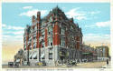
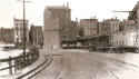
CENTRAL UNION STATION
By 1873 three passenger and as many freight depots
lay scattered along Front, Pearl, Fifth, and Sixth Streets in the West End, with
their multiplying tracks even back then threaten to become an impassable tangle.
In 1873 the directors of all these railroads formed a committee to consider the
construction of a single station to be used jointly by all. This committee came
to the conclusion that it would be impracticable because it could not be located
as to accommodate both the East and West roads. No further steps were taken for
the next eight years.
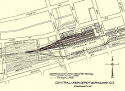
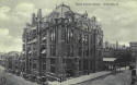
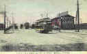
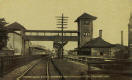
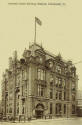
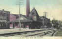
In 1881 the President of the Cincinnati, Indianapolis, Saint
Louis and Chicago Railroad, Henry Lord, was authorized by the directors to
acquire additional property in the West End, extending west from Central Avenue
to Smith Street between Pearl and Third, for a new union station. Work began on
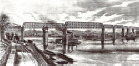
the depot in 1881 and was opened April 9, 1883. The three story head house was
on the corner of third and Central with the train shed wide enough for eight
tracks and five platforms that covered 215' of the 565' total length. This
length was eventually extended to 910' on number five platform. The 2nd image
below is not a postcard.
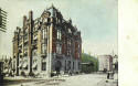
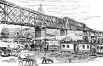
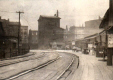
When this depot first opened in 1883 only two railroads used it, the proprietary company, Cincinnati, Indianapolis, Saint Louis and Chicago Railroad (Big Four), and a single tenant, the Cleveland, Columbus, Cincinnati and Indianapolis. But very quickly two more tenants joined, namely, the Ohio and Mississippi and the Cincinnati, Washington and Baltimore , the successor to the Marietta and Cincinnati. More railroads quickly joined the depot near the end of the 1880's. They were the Chesapeake and Ohio, Cincinnati, New Orleans and Texas Pacific, lessee of the Cincinnati Southern, the Kentucky Central, the B. O. (until they moved into the C.H.&D. in 1918) and the Eire Railroad.
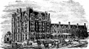
Early lithograph of depot
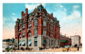

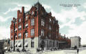

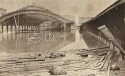
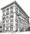
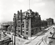
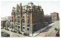
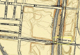
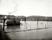
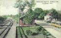
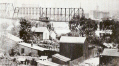
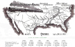
The map above shows all the Big Four's routes and apparently every depot it used. The 2nd photograph shows the terminal during the 1883 flood. The last image is of the Big Four Office Building located on 3rd Street adjacent to the depot.
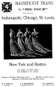
An early Big Four Ad.
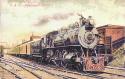
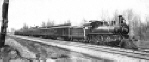
C & O Passenger Train
Kraemer postcard
Railroads used by the Central Union Depot : Cleveland, Cincinnati, Chicago, & St. Louis (CCC&StL) (Big Four); Baltimore & Ohio; Cincinnati, New Orleans, and Texas Pacific {CNO&TP); Louisville & Nashville (L&N); Chesapeake & Ohio (&O); Cincinnati Northern (NYC); Illinois Central R.R.
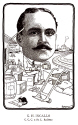
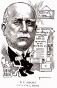
G. H.
Ingalls
L. E.
Osborn
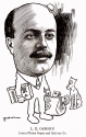
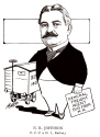
N. R.
Johnson
E. F. Osborn
General Freight Mgr. Treasurer Big
Four General Freight
Agt. Secretary Big
Four
Big
Four
Big
Four
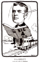
P. A.
Hewitt
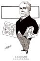
S. O. Bayless
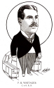
F. M. Whitaker
Big
Four Auditor Big Four
Lawyer
Freight Traffic Manager
C. & O. RR
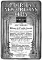
CINCINNATI SOUTHERN
RAILROAD
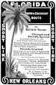
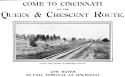
QUEEN & CRESCENT ROUTE
We now come to the only railroad in the country that is owned by a city. The city's need to open up a trade route from Cincinnati to the Southern States, because of the decline of the riverboat as a means of transporting goods and the railroads growing importance, prompted the city to ask Columbus in May of 1869 for permission to build a railroad line from the north bank of the Ohio River to Chattanooga, Tennessee, which was granted. . In June, in a special election, the question of constructing the railroad and issuing the bonds necessary to pay for it received a favorable vote of nearly 10 to one. The State of Tennessee granted a charter in January 1970, but the Kentucky Assembly did not act for more than two years before they authorized construction in February 1972. This was no doubt due to the influence of the competing L & N line pressuring the lawmakers. Construction began at Kings Mountain, in Lincoln County, Kentucky in December of 1873. The 332 mile length was completed in March of 1880.

![]()
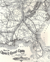
Route of the Cincinnati Southern
Basic Route
The Cincinnati Southern (CS) when completed cost a staggering $20,000,000 to build, or almost $60,000 per mile. By 19th century standards this was an unheard amount of money. The reason was the type of topography the railroad had to span. The stretch of line between Danville, Ky., and Oakdale, Tenn. contained 23 tunnels and has obtained lasting fame as the Rat Hole Division. This portion of the line was so crooked that a train that had over 120 cars would never be in a straight line. You add in 4 other tunnels in Kentucky from Wilmore, Kentucky to Danville, Ky. you have a total of 27 tunnels (bores) in a 150 mile stretch. In addition there are 105 bridges plus countless deep cuts and high hills. The line has since been improved to the point where there are only 13 bores remaining, 11 on the Rat Hole. All the bores had to be enlarged in 1928 due to larger engines and cars. The route is divided into 3 operating districts. From Cincinnati the First District extends 116 miles to Danville, Ky.; the Second District, the Rat Hole, spans 138 miles to Oakdale, Tenn.; and the Third District covers the final 78 miles to Citico Junction (Chattanooga).

Rat Hole section side view. (present day)
The city knew it did not have the necessary expertise to compete
with private carriers and within a year wisely leased the railroad to a
privately financed corporation. They awarded the lease, in September 1881, to a
New York financier Frederick Wolfe and the Erlanger family of Cincinnati. The
Wolfe-Erlanger group then established the Corporation named the Cincinnati, New
Orleans and Texas Pacific Railway Company or, more commonly known as the
CNO&TP. The portion owned by Cincinnati is still known as the Cincinnati
Southern Railway. These lines were all made possible because of the connections to New
Orleans and Texas from Chattanooga. The railroad became known as the Queen and
Crescent Route after the nicknames of the terminal cities of Cincinnati and New
Orleans.
The initial lease was for twenty-five years and to be renewable at
similar intervals thereafter. Rentals were $800,000 per year for five years,
$900,000 for the 2nd five, and $1,000,000 for the last fifteen. The lessee also
agreed to spend another $8,000,000 in improvements as directed by the trustees.
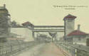
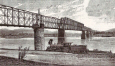
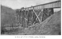
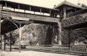
One of the major challenges facing the railroad was the
construction of a bridge spanning the Ohio. With a total length, including the
approaches, of nearly half a mile and with the river crossing itself of 1,500
feet, the bridge when completed would contain the longest truss span (515') in
the world at the time. The drawings below are all views as seen from the
Kentucky shore. All the images show the swing span that
was on the southern end of the bridge. It pivoted horizontally when it was
opened. This would allow river traffic to pass when the river level was too
high. When the bridge was rebuilt in 1922 this span was no longer needed,
although you can still see the pier that had supported it. The trains you see in
these images heading to the Ludlow Depot from Covington, KY. To see some
postcards of this bridge go to the Ohio River section.
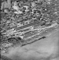
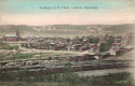
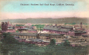
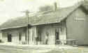
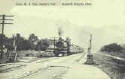
Until the Central Union Station was built in 1883 the CNO&TP depot was located in Ludlow, Kentucky. In the late 1880s they moved into Central Union. I had to use some of my Northern Kentucky cards for this section because not only was the depot there but the main railroad yard was also located there.
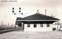
Ludlow
Depot
Southern Railroad
Yards
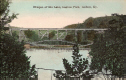
Trestle seen from the Lagoon Park in Ludlow
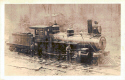
Locomotive #8
CNO&TP
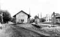
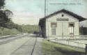
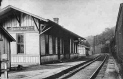
The two non-postcard images above show the CNO&TP
freight depot. Vine Street is on the East, Plum St. is on the West, Commerce St.
is on the North and Front St. is on the South side.
In the first 13 years of the lease agreement (1881-94) the total
rental paid to the city was $11,370,000. The total rental for the 25 years was
$23,500,000. The lease was renegotiated in 1902, four years before its
expiration date. The new lease was for 60 years at $1,050,000 per annum, for the
first 20 years, $1,100,00 for the 2nd 20 years, and $1,200,000 per year for the
3rd 20 years. The third part was raised in 1950 to $1,350,000 plus a varying
percentage of the net income. By the end of 1974 the rentals paid to the city
had reached a total of $156,000,000. From 1987 thru 2008 the rental payments
totaled $330 million including $18.9 million generated in 2008. The current
lease expires in 2026 with the option for renewal for 25 years.
Queen & Crescent
Routes More
detailed route map
C. N. O. & TP
Train
Not a Postcard
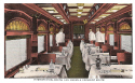
Q. & C. Parlor Car
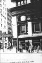
Ticket Office
4th & Vine
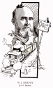
W. J.
Murphy
G. B.
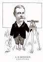
Nicholson
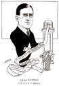
Charles
Patton
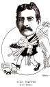
Alex. Telford
President Q. &
C. Chief Engineer Q. &
C. Treasurer Q. &
C. Purchasing Agt. Q. & C.
1903
1906
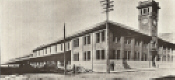
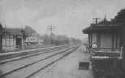
THE EIGHTH STREET DEPOT
In 1904 the Chicago, Cincinnati and Louisville Railroad completed a line between Cincinnati and Chicago along the shortest route between the two cities. The only way it could enter Cincinnati was over Cheviot Hill at an elevation 360 feet above its tracks in the Mill Creek Valley. This would entail steep grades in addition to expensive bridge and trestle work. The high cost of building the road plus a poor traffic left it unable to meet interest charges, and even in some years its operating expenses, and was only saved from total collapse when it was sold at foreclosure to the C. & O. in July of 1910. The depot for this railroad was a combined freight and passenger station on McLean Avenue near Eighth Street in 1903-04. This depot was the furthest from the city's core then any other station. After the C. & O. acquired the C. C. & L. property the passenger trains were transferred to the Fourth Street Station. The last non-postcard image below shows the depot during the 1913 flood.
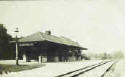
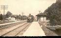
THE C. & O. / FOURTH STREET DEPOT
The C. & O. established service into the city in January, 1889, following the opening of the C. &. O. Bridge in 1888. Anticipating a larger volume of traffic that in fact never materialized, plans were made to build freight and passenger station in the block bounded by Third and Fourth Streets immediately north of the Union Depot train shed. The freight station was built as planned, but the passenger facility proved to be something of a joke. In 1891 the road bought a dwelling on Fourth Street near Smith that had been built in 1869. The rail road laid down track on both sides of the house, converting the parlor into a waiting room, the dining room into a ticket office, the kitchen into a toilet and lavatory, and the upstairs bedrooms into offices. Thus the Fourth Street Station was born. The station was used by the Kentucky Central (which later merged with the L. & N.) in addition to the C. & O.. Up to 10 trains a day used the depot.
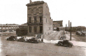

These 1929 non-postcard images of the C. & O. Depot show how the converted row house was located at the correct elevation for access to the C. & O. Bridge. The first image also shows the approach tracks to the Central Union Depot that went under the steel bridge the train is going over. The 2nd and 3rd images shows the depot from the rear, the last is just a great image with a little coke thrown in.
Railroads that used the Fourth Street Station in 1920: Chesapeake & Ohio; Louisville & Nashville.
It was nearly 30 years before Union Terminal came along and unified all the railroads into one facility. Despite the dissatisfaction with the confusing tangle of depots and tracks thru out the city it was still quite efficient in transferring freight and passengers into and out of Cincinnati. In 1890 276 trains entered and left each day, in 1910 243 trains came and went each day. These totals must be increased by 10 percent for those trains not shown in the public time tables, namely, mail and express trains, work trains, extra trains for those busy times. In 1920 289 trains passed thru, and it fell to 224 daily in 1928.
Cincinnati Railroads
The image above lists every railroad that used Cincinnati depots over the years.


Soo Line
This double card was put out for the district passenger agent for the Soo Line Railroad. That is not Cincinnati and I do not know what city it is. The Soo Line is now a branch of the Canadian Pacific Railroad and the "Soo" comes from the pronunciation of the word Sault that was part of its original name of Minneapolis, St. Paul and Sault Ste. Marie Railway (MStP & SSM). I have not discovered what depot was used back then, but when I do I will move this to the proper area.
TICKET OFFICE LOCATIONS
Big Four - Northwest corner of 4th & Vine
B. & O. - Southeast corner of 4th & Vine
C. H. & D. - Chamber of Commerce building, Southwest corner of 4th & Vine
Pennsylvania R. R. - Northeast corner of 4th & Vine
Queen & Crescent - 4th & Race
Erie R. R. - 11 west 4th St. (Mitchell building)
C. & O. - Southwest corner of 5th & Walnut
L. & N. - Southeast corner of 5th & Vine
Illinois Central - 423 Vine St.
ALL OTHER DEPOTS (in no particular order)
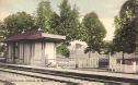
When the Union Terminal unified all the downtown depots into one building it also replaced this suburban depot that was operated by the Pennsylvania Railroad. Built in 1907 about five miles east of the Pennsylvania Station, its passengers came from the affluent Walnut Hills area. The location was between Riverside Drive & Columbia Parkway northwest of St. Rosa Roman Catholic Church. President William Howard Taft used this station during his term in office. The tower on the right contained an elevator that was used by the President's wife who was confined to a wheelchair. The tower and elevator were necessary because the depot was built into the side of a hill. It was closed in 1933.
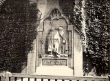
The two non-postcard images above show the station a little clearer and shows the sculpted panel underneath the overhead passage that was done by the sculptor Carl Bitter. It was one of a series of eight, representing important mid-western cities, that were done for the old Broad Street station in Philadelphia. They graced the walls of the station from 1881 until it was destroyed by fire in 1923. This sculpture was then sent here to be hung.
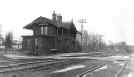
C. H. & D. Depot,
Northside
The Northside depot was located at the corner of Apple St. and Vandalia Ave was opened in 1851 which made Northside Cincinnati's first commuter suburb. The C.H.&D. depot was purchased by the B. & O. Railroad in 1917. It ceased operating in 1966.
Rendcomb Junction was created in the 1890's on the east side of Eastern Ave. about 400' north of Heekin Ave.
 *
*
Harrison Ohio
Depot
Big Four
Hartwell Depot
CH&D Hartwell-1918
Not a postcard
The Harrison Depot was located on the south side of Broadway St. at Railroad Ave. It was used by the Big Four.
EPWORTH HEIGHTS
Epworth
Heights Penn.
Depot
Penn Flier Epworth
Heights
Not a postcard

Milford Penn.
Depot
Kings Mills Penn. Depot
FOR MORE OF THESE
CARDS ![]()