![]()
![]()
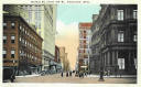
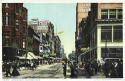
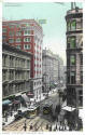
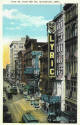
FIFTH STREET
These six cards all are Looking North on Vine Street from Fifth Street.
1928 Photograph
Vine St. From 5th
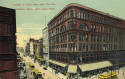
Large 1910 Photograph
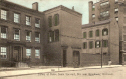
5th & Race Streets
I will try and explain some of the buildings you can see in the last six postcards and 1 very large photograph. I will be referring to the last two cards above mainly. The building on the right in both cards is the Mabley & Carew Department Store which occupied this spot for many years. The 4 story building across the street on the northwest corner (center card) was torn down and replaced by the twelve story Rollman's and Sons Department Store. Across the alley to the right of this building was the Hotel Havlin. When the Havlin closed, Rollman's purchased it, removed the alley, opened up the walls and connected the two buildings together thus expanding Rollman's retail space. After Rollman's closed Mabley & Carew moved across the street to this building. After the Carew Tower was constructed on the southwest corner Mabley & Carew moved into that building, they thus had occupied three of the four corners of fifth and Vine Sts. Of course Fountain Square now occupies the northeast corner. To the right of the Hotel Havlin is another alley and then the facade of the Grand Opera House which was rebuilt and eventually replace in 1939 by the Grand Theater. The next building north of the Grand at the southwest corner of Sixth & Vine was the Greenwood Building which was home to the Ohio Mechanics Institute from 1848 to 1910.. Barely seen across the street on Sixth is the Palace Hotel (now known as the Cincinnatian Hotel.). To the north of the Mabley & Carew building on the east side of Vine Street, across the street from the Grand) was the Lyric Theater. Opening in 1906 it presented musicals, vaudeville, and stage dramas before switching over to film. The Lyric closed in 1952 and was replaced by a parking lot. Across another alley is the Star Clothing Co. and next to it was the Family Theater a vaudeville house and then, by the 20s, a second run movie theater. The Family became the Western in the 1940s. When the Lyric was razed in 1952, the Western was remodeled and became the New Lyric but only lasted for less than a year. It was torn down 4 years later.
Corner of Fifth and
Walnut
Looking North on
Walnut
Looking North on Main
SIXTH STREET
East from
Elm 40
West 6th St.
North on
Sycamore
South on
Vine
Real Photo
PC


North on
Race
Corner of Walnut St.
6th St. near Broadway
6th St. East From Vine
Photograph
SEVENTH STREET

 *
*
South on
Race
North on Elm
Seventh & Race
EIGHTH STREET
NEAR NINTH STREET
CENTRAL PARKWAY
The new Central Parkway that replaced the old Miami-Erie Canal and covered up the city's failed attempt to build a subway system was dedicated over a three day span, from October 1 to 3, 1928. The 4 and a half mile boulevard ran from Broadway Street to Ludlow Avenue at a cost of $4 million. The old North and South Canal Streets were replaced by 4 lane (1 for parking) one way streets
THIRTEENTH STREET


